Log in
All resources
Create a design
475 Free Images of 1860 Maps
gemeente atlas van nederland - south holland
1860s maps of south holland
gemeente atlas van nederland - north holland
1860s maps of north holland
media from regionaal archief alkmaar
krimpenerwaard in the 19th century
george hayward
hoeksche waard in the 19th century
maps of polders in south holland
spijkenisse in the 19th century
1860 valentine map of new york city
george hayward
gemeente atlas van nederland - south holland
1860s maps of south holland
1860 valentine map of new york city
george hayward
gemeente atlas van nederland - south holland
1860s maps of south holland
gemeente atlas van nederland - north holland
maps of diemen
gemeente atlas van nederland - north holland
maps of diemen
gemeente atlas van nederland - south holland
strevelshoek
gemeente atlas van nederland - south holland
1860s maps of south holland
gemeente atlas van nederland - north holland
maps of amstelveen
books published in saint petersburg
boris andreevich dorn
gemeente atlas van nederland - south holland
1860s maps of south holland
gemeente atlas van nederland - south holland
1860s maps of south holland
gemeente atlas van nederland - south holland
maps of heerjansdam
gemeente atlas van nederland - south holland
1860s maps of south holland
gemeente atlas van nederland - south holland
1860s maps of south holland
gemeente atlas van nederland - south holland
19th-century maps of rotterdam
gemeente atlas van nederland - south holland
1860s maps of south holland
chicago and the midwest, newberry library
cartographic reliefs
gemeente atlas van nederland - south holland
maps of delfshaven
gemeente atlas van nederland - south holland
1860s maps of south holland
gemeente atlas van nederland - south holland
maps of hendrik-ido-ambacht
gemeente atlas van nederland - south holland
1860s maps of south holland
gemeente atlas van nederland - south holland
1860s maps of south holland
gemeente atlas van nederland - north holland
1860s maps of north holland
gemeente atlas van nederland - north holland
old maps of edam
hamburger stadtentwässerung
1864 maps of hamburg
gemeente atlas van nederland - south holland
maps of ameide
gemeente atlas van nederland - south holland
maps of haastrecht
gemeente atlas van nederland - south holland
1860s maps of south holland
gemeente atlas van nederland - south holland
1860s maps of south holland
gemeente atlas van nederland - groningen
maps of appingedam
gemeente atlas van nederland - south holland
maps of schipluiden
gemeente atlas van nederland - south holland
1860s maps of south holland
1860s maps of china
1863 maps of asia
maps in the rijksmuseum amsterdam
published by frans buffa & zonen
gemeente atlas van nederland - south holland
old maps of eiland van dordrecht
gemeente atlas van nederland - south holland
1860s maps of south holland
gemeente atlas van nederland - north holland
maps of bergen, north holland
gemeente atlas van nederland - south holland
1860s maps of south holland
media from regionaal archief alkmaar
old maps of koedijk
hakodate city central library
maps by takeshiro matsuura
gemeente atlas van nederland - south holland
maps of krimpen aan de lek
gemeente atlas van nederland - south holland
1860s maps of south holland
gemeente atlas van nederland - south holland
maps of monster, netherlands
portraits by charles-philippe larivière
neoclassicism
gemeente atlas van nederland - north holland
maps of schermer
gemeente atlas van nederland - north holland
19th-century maps of amsterdam
gemeente atlas van nederland - south holland
1860s maps of south holland
media from regionaal archief alkmaar
maps of wieringen
media from regionaal archief alkmaar
maps of texel
gemeente atlas van nederland - south holland
1860s maps of south holland
history of alphen aan den rijn
maps of benthuizen
gemeente atlas van nederland - south holland
1860s maps of south holland
gemeente atlas van nederland - south holland
1860s maps of south holland
maps by takeshiro matsuura
old maps of ezo
gemeente atlas van nederland - south holland
maps of nieuwenhoorn
gemeente atlas van nederland - south holland
giessen (river south-holland)
gemeente atlas van nederland - south holland
giessen (river south-holland)
gemeente atlas van nederland - south holland
maps of waddinxveen
gemeente atlas van nederland - south holland
1860s maps of south holland
maps of nieuw-helvoet
nieuw-helvoet
media from regionaal archief alkmaar
maps of heiloo
media from regionaal archief alkmaar
maps of wieringerwaard
media from regionaal archief alkmaar
maps of heerhugowaard
gemeente atlas van nederland - north holland
old maps of amsterdam
gemeente atlas van nederland - south holland
1860s maps of south holland
manual of the corporation of the city of new york (1864)
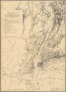
maps showing 1776
maps of the new york and new jersey campaign
maps showing 1776
gemeente atlas van nederland - south holland
old maps of brielle
media from regionaal archief alkmaar
old maps of schagen
gemeente atlas van nederland - south holland
1860s maps of south holland
gemeente atlas van nederland - south holland
1860s maps of south holland
gemeente atlas van nederland - south holland
19th-century maps of rotterdam
gemeente atlas van nederland - south holland
19th-century maps of rotterdam
gemeente atlas van nederland - north holland
old maps of alkmaar
gemeente atlas van nederland - south holland
1860s maps of south holland
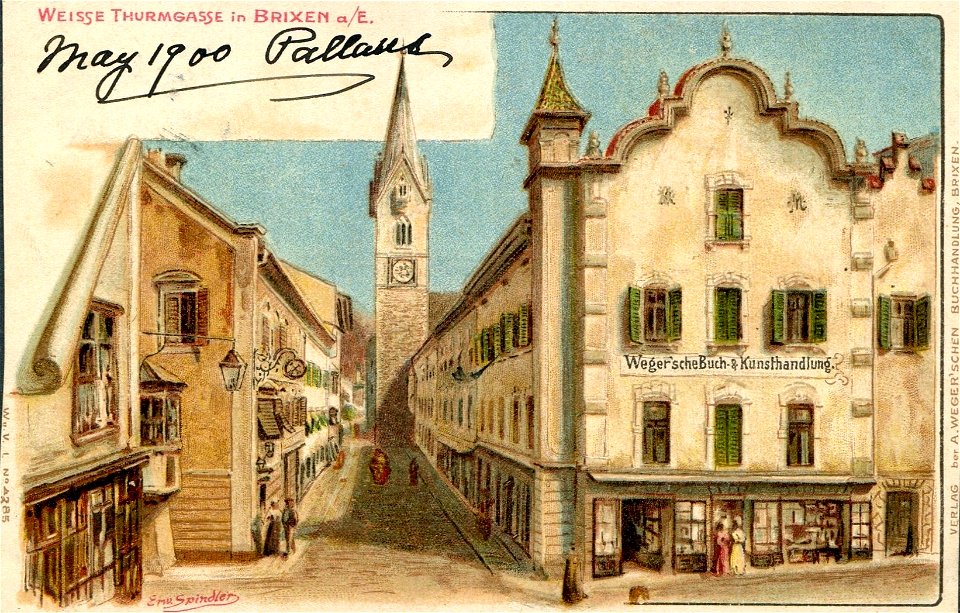
saint michael (brixen)
postcards of brixen
gemeente atlas van nederland - south holland
1860s maps of south holland
gemeente atlas van nederland - south holland
maps of zoeterwoude
gemeente atlas van nederland - south holland
1860s maps of south holland
gemeente atlas van nederland - south holland
1860s maps of south holland
gemeente atlas van nederland - south holland
1860s maps of south holland
gemeente atlas van nederland - south holland
1860s maps of south holland
media from regionaal archief alkmaar
oudkarspel
postcards by erwin spindler
postcards of meißen
gemeente atlas van nederland - north holland
maps of beemster
gemeente atlas van nederland - south holland
maps of lisse
gemeente atlas van nederland - south holland
maps of spijkenisse
gemeente atlas van nederland - south holland
maps of zoetermeer
gemeente atlas van nederland - south holland
1860s maps of south holland
gemeente atlas van nederland - south holland
maps of piershil
gemeente atlas van nederland - south holland
maps of goudswaard
cornell's primary geography (1860)
1867 maps of africa
gemeente atlas van nederland - south holland
old maps of leiden
gemeente atlas van nederland - south holland
old maps of gouda
gemeente atlas van nederland - south holland
old maps of gouda
gemeente atlas van nederland - south holland
maps of kethel en spaland
gemeente atlas van nederland - south holland
maps of alkemade
gemeente atlas van nederland - south holland
maps of zuid-beijerland
media from regionaal archief alkmaar
maps of barsingerhorn
101 - 200 of 475
Next page
/ 5